

A spectacular hillfort overlooking a tiny Aberdeenshire village has been revealed as one of the largest settlements from the Pictish period between the 3rd and 6th centuries CE.
Archaeologists from University of Aberdeen have uncovered evidence of more than 800 huts perched high on the slopes of the Tap O’ Noth close to the village of Rhynie in northeast Scotland.
Pictish date was a surprise
Radiocarbon dating suggests the lower fort ramparts and two of the excavated hut platforms were constructed in the fifth to sixth centuries CE and that settlement on the hill may date back as far as the third century CE.
Their discovery means that the area, which today is a quiet village home to just a few hundred people, once had a hilltop settlement that at its height may have rivaled many post-Roman settlements.
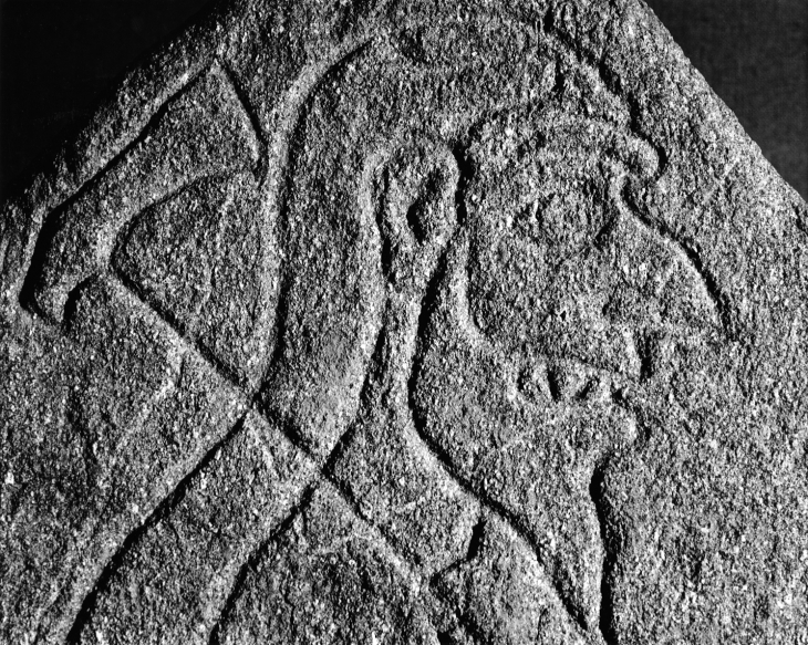
Archaeologists have conducted extensive fieldwork in the surrounding area since 2011 but had previously focused on the lower valley which was well known for its Pictish heritage thanks to the famous Rhynie Man standing stone found on Barflat farm.
A wide trade network
During excavations at the settlement in the valley they discovered evidence of Mediterranean wines and the use of glass vessels from western France as well as intensive metalwork production which suggested it was a high-status site, possible even with royal connections.
However, the hillfort overlooking it at the top of Tap O’ Noth had generally been assumed to date from earlier prehistoric periods.
Professor Gordon Noble, who led the research, described the discovery through carbon dating that activity at the site extended into the Pictish period as the ‘most surprising of his career’.
Understanding the site as a whole
“I was absolutely stunned when I read the results,” he said. “We took samples from the site really just to begin placing the important discoveries we have made at Rhynie over the last few years in a broader geographical context.
“Because of the sheer scale of the fort and its location clinging to the side of a hill at the edges of the Cairngorms, some scholars had suggested occupation dated from a time when the climate was warmer, possibly during the Bronze age, and our earlier excavations have shown the vitrified fort on the summit of Tap O’ Noth dated to 400-100 BC.”
“Over the last two years we have been investigating the lower fort at Tap O’ Noth which is enclosed by a rampart that encircles the lower slopes of the hill.
“The results of the dating were simply incredible. They show that the huge enclosed area dated to the fifth to sixth centuries AD and that it was occupied at the same time as the elite complex in the valley at Barflat farm. Dating shows that settlement on the hill extended as far back to the third century, but both hut platforms excavated also had fifth to sixth century AD phases.”
The Aberdeen team then conducted drone surveys and utilised LiDAR technology which showed that there are hundreds of hut platforms within the bounds of the lower fort – perhaps as many as 800 – making it one of the largest settlements discovered in Scotland from this time period.
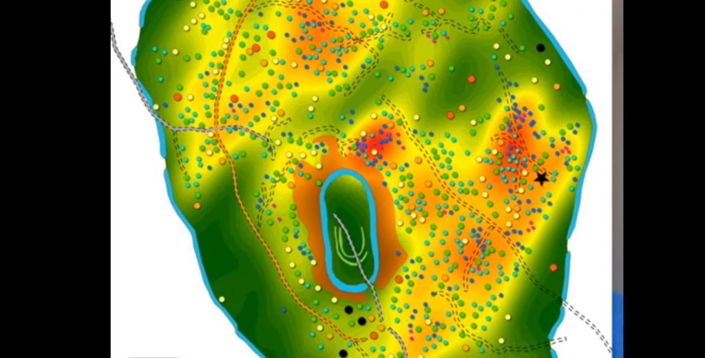
The distribution of the buildings suggests they are likely to have been built and occupied at a similar time as many are positioned alongside trackways or clustered together in groups. Drone surveys also showed that within these groups was one notably larger hut, indicating that there may have been some form of hierarchical organisation within the fort.
Professor Noble added: “The size of the upper and lower forts together are around 16.75 hectares and one phase at least dates from the fifth to sixth centuries AD.
“This makes it bigger than anything we know from early medieval Britain – the previous biggest known fort in early medieval Scotland is Burghead at around five and a half hectares and in England famous post-Roman sites such as Cadbury Castle is seven hectares and Tintagel around five hectares.
We had previously assumed that you would need to get to around the 12th century in Scotland before settlements started to reach this size. We obviously need to do more to try and date more of the hut platforms given there are hundreds of them, but potentially we have a huge regional settlement with activity emerging in the Late Roman Iron Age and extending to the sixth century. It just shows just how much we still have to learn about settlement around the time that the early kingdoms of Pictland were being consolidated.”
Bruce Mann, Archaeologist for Aberdeenshire Council said: “To say these results are completely unexpected is an understatement. However, they could be key to understanding changing settlement patterns at the time. In the early centuries AD there were widespread small communities scattered across the landscape. These then largely disappear during the time of the Roman campaigns and we’ve struggled to understand what happened. Perhaps now we have evidence of people coming together in large concentrations at a handful of places, a reaction to the threat of external invasions.”
Permission to excavate and film at Tap O’ Noth was granted by Historic Environment Scotland and supported by Aberdeenshire Council. The fieldwork was funded by the University of Aberdeen Development Trust and Historic Environment Scotland.